Amazing Limited Time Offer !
Call : +91 7771811100, +91 7771811104
Accurate Surveying and Construction



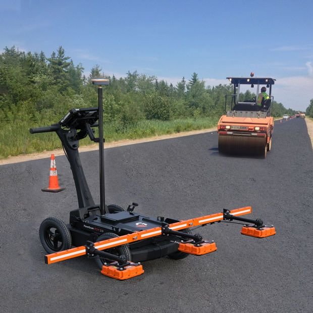
Construction projects today demand accurate details concerning both surface as well as subsurface conditions. Prior to excavation, piling, foundation construction, road construction, utility laying, and modification of structure, knowledge about the subterranean conditions can be of great help to engineers to plan their task effectively. Pipeline, electrical cables, drainage systems, previous foundations, voids, and different layers of soil can affect the construction process. A professional Ground Penetrating Radar Survey in Vijayawada offers a non-invasive technique to study the subsurface conditions. Ground Penetrating Radar is often referred to as GPR that works with the help of electromagnetic waves to discover any change in the subsurface conditions.
ASurvey offers you GPR Survey, geotechnical investigation, soil testing, drilling of boreholes, piling investigation, DGPS, Total Station, and many other surveying and engineering services.
GPR is a non-invasive geophysical surveying technique that works on the principle of imaging below the ground level through the use of high-frequency radio waves. No digging, drilling, or cutting of concrete is required for the survey, hence the area remains unaffected during the process and provides you with accurate results.
The instrument emits electromagnetic waves into the ground. When one of those waves encounters a buried item or a transition point of materials, such as a pipe, void, rebar, or soil layers, some portion of the wave gets reflected back to the antenna.
Vijayawada is an essential commercial and infrastructure center with development in terms of residence, industries, transportation, roads, bridges, railways, and infrastructure projects. The location of the city along the Krishna River makes certain sites vulnerable to having varying soil conditions and groundwater.
ASurvey’s specific information for Vijayawada emphasizes the soil conditions along the banks of the river, dense infrastructure below ground in urbanized sites, groundwater, and existing structures as potential influences on construction and piling projects.
1. Detecting Underground Utilities
There is often the challenge of detecting utilities while excavating. GPR surveying can help identify the possibility of water pipelines, electrical cables, drainage pipes, and communication ducts.
Utility mapping before trenching, drilling, or laying foundation will give information on any existing underground utilities.
2. Investigating Construction Sites
Construction sites often have remnants of former sites, which include old foundations, debris, underground utilities, and other underground utilities. GPR surveying makes it possible to investigate such sites by scanning selected sections without excavation.
This is important for construction, redevelopment, and renovations and other new infrastructural works.
3. Investigating Roadways and Pavements
Road and pavement structure have many layers underneath and GPR can make it easier to detect changes, anomalies, and cavities under selected regions.
Information obtained from such an investigation can aid in paving repairs and widening and construction of new pavements.
4. Concrete and Rebar Detection
The same technology of GPR can be used in concrete and rebar investigation. This is important for detecting embedded reinforcement bars and conduits before drilling or making any alterations to any structures.
It is applicable in buildings, bridges, slabs, and other industrial facilities.
A professional Ground Penetrating Radar Survey in Vijayawada usually involves a well-defined process.
Step 1: Site Inspection
This step includes the review of project requirements, site details, existing drawings, construction details, and areas that need to be surveyed.
Step 2: Survey Plan
In this stage, the survey grid, survey lines, instrument setting, and frequency of antenna that needs to be used are selected depending on site and project requirements.
Step 3: GPR Data Collection
The GPR instrument is dragged in the specified survey area for collecting electromagnetic reflections from subsurface objects.
Step 4: Data Processing
This step involves the processing of collected GPR data using appropriate software for analyzing the relevant signals and subsurface anomalies.
Step 5: Data Interpretation
The interpretation of radar profile is done by experts in order to identify potential utilities, buried objects, cavities, reinforcement, soil boundaries, and other subsurface objects.
Step 6: Verification
If necessary, the GPR results can be verified through boring, excavation, inspection, soil samples, or other investigation techniques.
Step 7: Reporting
Survey results can be provided in the form of GPR profiles, maps, drawings, observations, images, and reports based on project requirements.
While GPR can produce some helpful mapping data, it cannot entirely take the place of geotechnical investigation.
GPR may be used to locate some of the subsurface elements, while boreholes and soil tests can give details on soil characteristics, stratigraphy, water table, and other foundation related factors.
This is why a combination of Ground Penetrating Radar Survey at Vijayawada along with geotechnical investigation may lead to better understanding of the area.
ASurvey offers such services as borehole drilling, soil testing, Standard Penetration Testing, lab testing, geotechnical investigations and piling investigation in Vijayawada.
There are a number of industries that can benefit from GPR surveys in Vijayawada and its vicinity, which include the following:
All of the above industries indicate the versatility of the GPR survey.
ASurvey offers surveying and engineering investigation services with advanced instruments and highly skilled technical staffs. The services that are offered by ASurvey in their Vijayawada branch include ground penetrating radar survey, geotechnical investigation, soil testing, borehole drilling, piling investigation, underground utility detection, and other engineering investigation services.
The list of surveying and investigation equipment used by the organization also includes DGPS, total station, auto level, GPS, soil testing, borehole drilling machines, and digital data collection instruments.
Correct information about subsurface conditions can assist in better planning of construction projects and avoidance of any problems which may arise while excavations and foundation works. Ground Penetrating Radar Survey in Vijayawada offers an effective way to analyze underground utilities, structures, voids, soil stratigraphy, steel reinforcement in concrete and other subsurface objects.
In conjunction with geotechnical investigation, drilling of boreholes, soil analysis, piling investigation, DGPS, Total Station and other necessary surveying methods, GPR can be an important source of information when constructing buildings or infrastructure projects.
If you plan residential, commercial, industrial, highway, railway, bridge, utility and government infrastructure projects in Vijayawada, feel free to contact ASurvey regarding your Ground Penetrating Radar and subsurface investigation needs.