Amazing Limited Time Offer !
Call : +91 7771811100, +91 7771811104
Accurate Surveying and Construction



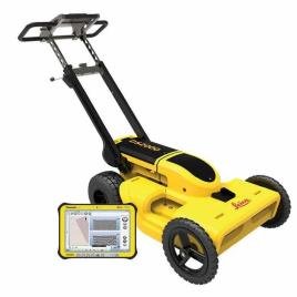
Modern projects in construction and infrastructural development need more than just information regarding the ground surface. Information on underground pipelines, cables, drainage systems, cavities, built-up structures, and other underground features can be very problematic during construction work that starts without prior knowledge of the underground features. A Ground Penetrating Radar Survey in Haryana is one of the modern and non-invasive techniques for discovering underground features before excavation and drilling.
There have been tremendous developments in residential areas, industries, highway construction, commercial buildings, urban infrastructure, and utility networks in Haryana. With the increase in developments, it has now become a critical component in planning the project itself. An expert GPR Survey in Haryana can provide you with valuable underground information along with minimizing the excavation work involved.
Ground Penetrating Radar is referred to as GPR and is a geophysical surveying technique that uses electromagnetic waves of radar to survey what lies beneath the surface of the ground or structures. It involves sending radar waves through the surface and capturing any reflections of the waves because of the variation in subsurface material.
The reflections allow surveyors to detect possible features or voids beneath the surface or buried structures. GPR is applied in utility surveys, archaeology, roads, and engineering work. According to the government data from Gurugram Metro Rail Limited, ground penetrating radar is described as a non-destructive imaging of subsurface structures and objects.
Haryana encompasses fast-developing urban areas, industrial areas, transport areas, institutional areas, and rural infrastructures. However, the underground utilities present are not always visible from above. Thus, it becomes crucial for construction teams to have reliable information about the area before beginning any digging/drilling operations.
The benefits that GPR Survey in Haryana can bring about through project planning by aiding professionals in investigating the subsurface conditions prior to construction processes are as follows:
1. Detection of Underground Utilities
The detection of underground utilities is one of the most frequent applications of GPR technology. The electrical cables, pipelines, drainages, and other buried facilities could be the cause of trouble during any excavation activity or building work.
It becomes possible to have a clear idea about the presence of any underground facility through a GPR survey in Haryana.
2. Analysis of Roads and Highways
In order to get information related to pavement layers, the presence of utilities in underground and subsurface anomalies, road construction projects may require such analysis.
Such a process may be helpful for highway investigation and roads of urban area, industry and any other transportation network.
3. Investigation of the Construction Site
In case any project team needs information regarding the subsurface condition prior to any foundation, trenching, pile or other construction activity, ground penetrating radar survey in Haryana is beneficial.
4. Archaeological Surveying
The GPR technique is also effective in conducting an archaeological survey as it allows surveying of the subsurface features without having to disturb the site at first place. GPR survey has been successfully employed for an archaeological survey in Haryana: in the year 2024, a GPR survey has been initiated at Agroha archaeological site in Hisar.
5. Structural and Concrete Surveys
GPR surveying techniques can also be used for structures and concrete surfaces for detection of rebar, embedded items, and voids within the structures and concrete surface.
Typically, a professional Ground Penetrating Radar Survey in Haryana uses the following procedure for data collection and interpretation.
Stage 1: Site Evaluation
The project requirements, site conditions, drawings, and the area to be surveyed are evaluated by the survey team.
Stage 2: Survey Planning
The survey method, grid, scan direction, equipment, and coverage are chosen in accordance with the goals of the project.
Stage 3: Radar Data Acquisition
The GPR survey equipment is moved over the area that should be surveyed. Signals are emitted into the subsurface from the equipment and the returning signals are recorded.
Stage 4: Data Processing
Radar data obtained during the survey is processed in order to increase the accuracy of data interpretation. Experienced specialists evaluate the data to determine the targets from other subsurface signals.
Stage 5: Data Interpretation and Presentation
The data can be represented by means of certain survey drawings, profiles, interpretations, and project reports. The type of deliverables depends on the goals of the survey.
Using GPR Survey in Haryana may be of great assistance to many stakeholders within projects.
Improved planning of the project: Knowing the conditions of the subsurface layer can assist in making better plans for excavation and construction works.
Decreased excavation work: Using non-invasive investigation methods can decrease excavation work that is not needed in certain cases.
Improved safety: Detection of utilities at the subsurface layer can help prevent their damage during excavation work.
Time savings: Using GPR can cover certain designated areas without damaging the surface.
Cost savings: Information regarding the conditions of the subsurface layer will help to decrease unnecessary excavation and utility damage.
GPR data demands suitable tools, methods, processes, and interpretation skills. Therefore, choosing a competent surveying firm becomes imperative where the outcome impacts engineering or construction choices.
Accurate Surveying and Construction offers professional services in surveying and engineering consultancy and lists various types of surveying, including GPR, DGPS, drone survey, geotechnical survey, hydrographic survey, land survey, and more. It claims to work with civil engineers and surveyors and uses advanced surveying equipment.
In case you are looking for Ground Penetrating Radar Survey in Haryana, a professional team would assist you in determining the scope of the survey, doing field measurements, processing the data collected, and generating project-specific outputs.
Subsurface knowledge is very crucial for current construction, infrastructure, utility management, archeological, and engineering projects. Ground Penetrating Radar Survey in Haryana serves as a non-intrusive means of analyzing subsurface conditions selectively to aid in proper project planning.
Regardless of whether it involves underground utility locating or road investigations, GPR helps in obtaining necessary subsurface information without much of surface disruption. With the integration of other surveying and engineering practices, GPR becomes an integral element of site investigation approach.
If your project needs a reliable subsurface investigation, the Ground Penetrating Radar Survey in Haryana will enable you to know everything about the hidden site conditions before any excavation or construction starts. Accurate Surveying and Construction will be able to fulfill the needs of your project with its surveying and engineering services.
What is a GPR survey?
A GPR survey is a non-destructive geophysical study of subsurface features or material variations using radar signals.
What areas does GPR survey cover?
The use of GPR includes investigations related to underground utilities, roads, archaeological works, construction projects, and structural or concrete scans.
Can a GPR survey be conducted for construction projects?
Yes. The survey provides subsurface information which could help in planning excavations, locating utilities, and site investigation depending on site conditions.
Does GPR survey involve excavation?
Since it is a non-destructive method, GPR survey usually does not involve excavation only to acquire radar signals. However, there might be other investigation procedures needed to verify specific findings.
What is the accuracy of GPR findings?
GPR findings depend on soil condition, size of the target object or material, depth of the investigation, frequency of equipment used, surface conditions, and proper interpretation by professionals.