Amazing Limited Time Offer !
Call : +91 7771811100, +91 7771811104
Accurate Surveying and Construction



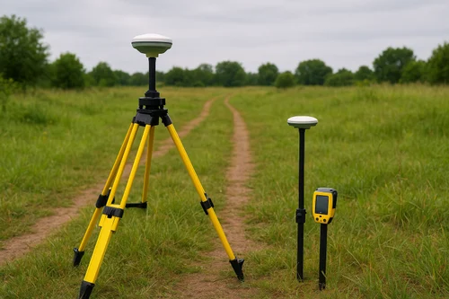
Geographical information is an essential component in many of today’s construction and infrastructural development projects. Traditional surveying methods could take a long time to complete due to the amount of manual work involved. However, new positioning systems offer a better solution, providing precise geographic coordinates and measurements on the ground. DGPS Survey in Karnataka uses Differential Global Positioning System technology in order to obtain accurate positional information for a variety of surveying and mapping needs. DGPS can be used for such purposes as land surveying, topographical mapping, infrastructural development, road construction, pipeline construction, mining, and others.
Accurate Surveying & Construction offers surveying and geospatial services using modern instruments and highly-qualified civil engineers and surveyors. The company uses such methods as DGPS, drone, GPR, hydrographic, topographical, land surveying and others.
DGPS means Differential Global Positioning System. It is a sophisticated surveying technique involving satellites which makes use of correctional information from reference stations to improve positional accuracy.
As opposed to GPS positioning, DGPS enables users to get more accurate positions hence it can be used for professional surveying purposes. Surveyors are able to carry out their surveying work using DGPS equipment to collect data about position, boundaries, alignments, elevation, among other information that may be relevant to the project.
This data is further processed to facilitate mapping, planning, design, construction, and documentation. Survey of India has defined GPS, CORS, and DGPS as geospatial technologies used for land mapping and field data collection.
In Karnataka, there is a large diversity of topography and developments that include urban development, industrial development, agricultural lands, mining zones, roads, and infrastructure corridors among others. This makes it possible for varied project conditions where there is a need for surveying data.
DGPS Survey in Karnataka will be useful for helping the projects set the correct coordinates and collect field data systematically.
Some of the benefits of the DGPS Survey in Karnataka include:
The Survey of India has even embarked on large scale mapping in Karnataka, an example of geospatial technology applications in land and property mapping in the region.
DGPS has the potential to serve many different sectors and projects. Some examples include:
1. Land and Boundary Survey
DGPS has the ability to determine coordinates of land plots and boundaries. Location information can be useful for land planning and mapping.
2. Road and Highway Surveys
Road construction projects need correct alignment, controls, levels, and location. DGPS surveying can help surveying crews with routing, construction, and monitoring.
3. Construction Projects
The construction firms can make use of DGPS data in their projects for site planning, setting out, coordinate determination, and other engineering needs.
4. Mining Surveys
Mines have wide extents of area where accurate spatial information is crucial. DGPS surveying can be useful in mine mapping, boundary determination, stock surveying, etc.
5. Pipeline Route Surveys
Correct identification of pipeline routes is needed in the pipeline projects. DGPS surveying can help collect coordinates for proposed and existing pipelines.
6. Topographical Mapping
DGPS may be used in conjunction with other surveying methods to gather positional information that is necessary for the process of topographical and contour mapping.
7. Industrial and Infrastructure Construction
Industrial plants, transmission lines, dams, bridges, and other types of infrastructural construction require reliable survey data. Coordinate data may assist in engineering design and construction activities.
Accurate Surveying and Construction specifically mentions construction and infrastructure, industrial and plant construction, mining and minerals construction, dam and hydro construction, and roads and pipeline construction among the areas it serves.
In general, a survey using DGPS technology will involve the following steps:
Step 1: Project Planning
The surveyor understands the scope of the project, its objectives, the necessary accuracy of the survey, the coordinate system to be used, and the deliverables.
Step 2: Creation of Reference Information
Suitable reference or correction information is created in accordance with the project requirements.
Step 3: Field Data Collection
Using DGPS equipment, the surveyor observes necessary points and takes down their geographical coordinates.
Step 4: Quality Control of Measurements
Measurements collected are checked for inconsistencies and whether the data satisfies project requirements.
Step 5: Processing of Data
Field data is processed using appropriate surveying and mapping software.
Step 6: Deliverables
Depending on the project, the deliverables could be in the form of coordinate data, maps, drawings, survey reports, etc.
Engaging professional DGPS Survey Services in Karnataka can offer many advantages for engineering and construction teams. Professional surveyors know about field conditions, coordinate systems, equipment operation, processing of data, etc.
Key advantages are as follows:
Correct Project Data
Correct coordinates make a more reliable basis for engineering design and project planning.
Efficient Field Work
Up-to-date DGPS equipment allows gathering big volumes of positioning data fast.
Improved Construction Planning
Correct information about the survey can help engineers and constructors better understand conditions before construction works commence.
Compatibility with Digital Data
Processed information can be included into GIS, CAD, mapping, and any other digital processes as needed.
Suitable for Large Projects
DGPS is applicable for various projects including single land survey and large infrastructure corridors.
Development of urban areas, industries, transport and mining infrastructure is still ongoing in Karnataka. Accurate spatial data is required for planning and developing Bengaluru city as well as other parts of Karnataka, while road works, pipeline networks, industrial construction and large plots of lands also require reliable survey data.
Survey of India has performed large-scale mapping activities in Bengaluru and adjacent districts using UAV/drone systems, which highlights the relevance of digital geospatial mapping for Karnataka.
Thus, a DGPS Survey in Karnataka can be an essential step in the surveying and engineering process.
Accurate Surveying & Construction offers services related to surveying skills, expert civil engineers, modern equipment, and technological methods. According to the organization, it started offering surveying and construction consultancy services in 2013 and emphasizes accuracy, timely services, safety, and cost-effectiveness.
The organization's surveying includes DGPS surveying, land surveying, total station surveying, topographic surveying and contour surveying, aerial drone surveying, GPR surveying, hydrographic surveying, mining surveying, pipeline route surveying, and many other surveying services.
For companies looking for reliable DGPS survey services in Karnataka, it will be beneficial to choose professionals who have appropriate equipment and field experience so that the acquired information meets the project's needs.
Spatial data plays a critical role in ensuring that land developments, constructions, infrastructures, mining, roads, pipelines, and industrial operations are done successfully. DGPS technology enables us to use a modern technique for gathering accurate geographic data and carrying out digital surveying operations.
The DGPS Survey in Karnataka can help your team gather accurate field data for planning, mapping, designing, and construction of projects. Using competent surveyors, modern surveying equipment, and proper data processing techniques, your DGPS surveying efforts will make your project well-executed.
If you need any surveying assistance, we at Accurate Surveying and Construction can provide you with DGPS surveying and other surveying and engineering services throughout India.