Amazing Limited Time Offer !
Call : +91 7771811100, +91 7771811104
Accurate Surveying and Construction



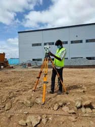
Accurate Surveying provides professional Demarcation Survey Services in Kerala for accurately identifying and marking property boundaries, land parcels, project limits, and right-of-way areas. Using modern DGPS and Total Station technology, experienced surveyors deliver reliable measurements, boundary marking, maps, and survey documentation for residential, commercial, industrial, infrastructure, and land development projects.
Accurate Land Boundary Identification with Demarcation Survey Services in Kerala Clear and precise land boundary identification is essential for property development, construction planning, land acquisition, infrastructure projects, and legal verification. Unclear boundaries can cause disputes, construction delays, encroachment issues, and complications for landowners and developers.
Demarcation Survey Services in Kerala help accurately identify, measure, and physically mark land boundaries using approved records, survey documents, and project-specific requirements. Experienced surveyors employ modern equipment and systematic field procedures to establish precise boundary points and deliver reliable documentation.
Accurate Surveying provides professional surveying solutions backed by skilled surveyors and advanced technologies such as DGPS and Total Station. Their demarcation surveys focus on accurately identifying property boundaries, land parcels, project limits, and right-of-way areas to support informed decision-making and project success.
A demarcation survey involves identifying, measuring, and physically marking the exact boundary lines of a land parcel using legal records, revenue documents, and survey settlement maps. This process re-establishes original boundary points on the ground with coordinates, boundary stones, or pillars, giving landowners a clear, undisputed understanding of their property limits.
Our expert team conducting Demarcation Survey Services in Kerala ensures every boundary point is fixed using scientifically accurate methods rather than assumptions, significantly reducing the risk of future disputes among neighbors, developers, or government authorities.
Kerala’s land ownership is unique, often featuring small, irregular plots passed down through generations by partition deeds. Over time, original boundary markers may shift, vanish, or become unclear. The state’s varied terrain—including hilly plantations, coastal properties, and backwater-adjacent lands—adds complexity to boundary identification.
Whether it’s a residential plot in Kochi, a plantation in Idukki, a coastal property in Alappuzha, or an industrial site in Kannur, our surveyors are well-equipped to address Kerala’s diverse and challenging terrain with precision and confidence.
Accurate Surveying follows a systematic approach to ensure reliable demarcation results:
Requirement Assessment
Understand client needs, property details, project objectives, available documents, and expected deliverables.
Document Review
Examine land records, approved plans, maps, coordinates, and relevant documents before fieldwork.
Site Inspection
Visit the site to study conditions, identify reference points, existing boundary markers, nearby structures, and features.
Precision Surveying
Use DGPS and Total Station to collect accurate coordinates, distances, and angles for precise boundary establishment.
Boundary Identification
Compare field data with records and project requirements to determine accurate boundary points.
Physical Marking
Mark boundary points with permanent or temporary markers for clear on-ground recognition.
Mapping and Reporting
Prepare maps, coordinates, drawings, measurements, and reports tailored to project needs.
These advantages make our services popular among landowners, builders, and institutions across Thiruvananthapuram, Kochi, Kozhikode, Thrissur, Kollam, and other Kerala districts.
If you own land in Kerala and need clear boundary identification, partner with a professional team combining legal knowledge and modern technology.
Book your Demarcation Survey Services in Kerala now for an accurate, legally sound boundary report.
Accurate Surveying provides professional Demarcation Survey Services in Kerala for accurately identifying and marking property boundaries, land parcels, project limits, and right-of-way areas. Using modern DGPS and Total Station technology, experienced surveyors deliver reliable measurements, boundary marking, maps, and survey documentation for residential, commercial, industrial, infrastructure, and land development projects.