Amazing Limited Time Offer !
Call : +91 7771811100, +91 7771811104
Accurate Surveying and Construction



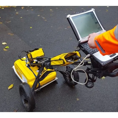
Construction projects involve obtaining necessary data not only on above-ground structures but also below-ground structures as well. Engineers need to have an idea about the potential obstructions in the ground before they start digging foundations, laying down pipelines, reconstructing roads, and even changing any structures. Lack of information on the underground conditions may result in extra work. The Ground Penetrating Radar Survey in Itanagar is a non-destructive method that can be used in order to study selected underground structures and obtain data for the further construction project development. This technology is based on the usage of electromagnetic radar waves to detect changes in the soil or structural material under investigation.
In the case of Itanagar, there are many construction and infrastructure needs including construction of various buildings, roads, drainage and other public works. As conditions of the ground may differ from one location to another, methods for their investigation should be chosen according to real project needs. A Survey is a company offering surveying and investigation services for construction, infrastructure, and industrial projects.
Ground Penetrating Radar or GPR refers to the geophysical surveying method that sends electromagnetic waves down into the ground or man-made construction. If there are any changes in the medium where the waves travel, part of the signal is reflected back to the receiver.
Reflections allow surveyors to detect possible buried objects and features.
The difference from traditional digging exploration is that GPR enables the inspection of particular areas without much digging.
However, the effectiveness of the method is based on soil type, soil moisture, target dimensions, depth, and other factors.
GPR survey can be helpful for detecting:
The results need to be professionally interpreted, and the most valuable targets should be confirmed by further inspections.
Construction on hills or in foothills often involves varied ground surface, sloping terrain, drainage needs, and existing underground infrastructure. This makes investigation necessary prior to excavation and construction activity.
Ground Penetrating Radar Survey in Itanagar can be valuable for some particular projects in which underground features need to be investigated prior to the commencement of work.
1. Building Construction and Renovation Projects
Construction of new buildings, renovations or extension works may need drilling or excavation close to existing constructions. GPR can be used to locate possible buried services and/or objects before commencing any intrusive works.
2. Roads and Drainage Construction
Improvements and development of roads and drainage systems may need investigation of existing utility paths, road layers, and other underground features. GPR survey can assist in investigating these issues prior to construction works.
3. Water Supply, Utilities and Communication Lines
Excavation may be difficult due to the presence of water pipelines, electricity cables, and communication lines underground. GPR may assist in identifying the location of such targets if favorable ground conditions are present.
4. Concrete Inspection
GPR is an applicable inspection method for reinforcement and conduits embedded in suitable concrete structures. Information from such inspection will be useful for designing drilling, cutting, or structure alteration activities.
Underground Utility Mapping
Underground utility mapping aids construction crews in knowing where the buried services could possibly be located within the proposed work area. The usefulness of GPR in identifying some metallic and non-metallic utilities is possible; however, this will depend on the size, depth, material composition, and the type of soil around them.
In case of critical excavation works, the survey findings have to be analyzed in conjunction with existing records and other locating methods.
Subsurface Anomaly Investigation
The presence of anomalies in the materials below ground level can result in unique radar responses, and these could imply the presence of buried items or void-like features.
Additional research might be needed to determine what the anomaly is all about prior to making engineering decisions.
Road and Pavement Evaluation
The evaluation of the pavement and thickness of layers below the surface of the road is one way how GPR can be useful. This information is used by road engineers in determining what further actions are needed.
In some cases, industrial projects, public structures, warehouses, and infrastructure projects would need an exploration of the subsurface environment before the installation of equipment or modification of any structure.
The use of an appropriate survey strategy will ensure that the data collected satisfies the project goal.
An effectively conducted study will involve a number of steps which ensure obtaining valuable and interpretable information.
Step 1: Determining the requirement
In this step, the study team determines the purpose of conducting a survey, e.g., utility locating, concrete scanning, pavement analysis, or detection of subsurface anomalies.
Step 2: Site review
Professional surveyors assess the available drawings, site access, surface conditions, and location of the survey.
Step 3: Choosing the equipment
Choice of the equipment depends on the target characteristics, material conditions, and investigation depth required.
Step 4: Gathering of radar information
The team conducts the survey and records reflected signals at the selected location according to the planned lines.
Step 5: Interpreting the results
Obtained radar information is analyzed to detect potential targets and subsurface patterns. Interpretation takes into account limitations of the equipment and local site conditions.
Step 6: Creating deliverables
As per the pre-defined agreement, the client may get the delivered survey drawings, locations of detected targets, observations, and a technical report. Locating or trial excavations are often required to confirm some of the findings.
In planning a Ground Penetrating Radar Survey in Itanagar, one should start by determining what kind of information is required for the particular project. An investigation aimed at finding out where utilities are may have different needs compared to the investigation meant to check concrete or pavement layers.
One should take into account the following before choosing a provider:
A Survey provides surveying services for construction, industrial, and infrastructure applications. One can talk to them about their requirements and determine whether GPR is applicable.
Having knowledge about underground conditions prior to construction will allow you to have an insight into any possible hurdles that might be faced during the execution of the project. Ground Penetrating Radar can prove to be an excellent tool for the investigation of selected buried utilities, concrete structures, pavement, and subsurface conditions.
Ground Penetrating Radar Survey in Itanagar can assist in building construction, road construction, drainage, utility survey, and infrastructure maintenance provided that the site conditions permit the interpretation of the same through proper equipment.
If you need any survey or investigation services, kindly check out http://asurvey.in/.