Amazing Limited Time Offer !
Call : +91 7771811100, +91 7771811104
Accurate Surveying and Construction



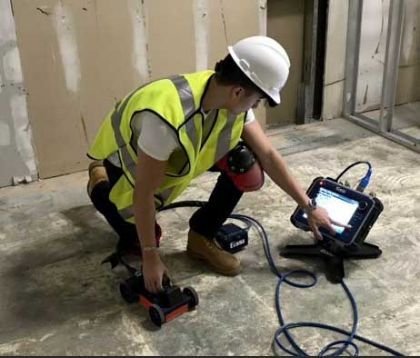
Construction and infrastructure projects increasingly require accurate subsurface information before excavation, drilling, foundation work, road development, or utility installation. Hidden elements such as pipelines, electrical cables, concrete structures, reinforcement, and cavities can pose unexpected challenges. A professional Ground Penetrating Radar (GPR) Survey in Gujarat offers a non-destructive method to assess subsurface conditions. Using advanced radar technology, experts collect data on underground features and detect potential anomalies without extensive digging.
A Survey provides specialized surveying and geophysical investigation services for construction, infrastructure, industrial, commercial, and engineering projects, helping teams obtain precise site information for improved planning and decision-making.
Ground Penetrating Radar (GPR) is a geophysical surveying method that uses electromagnetic waves to examine materials beneath the ground or within structures. The radar system sends signals into the surface and records reflections caused by changes in material properties.
These reflections are processed into radar profiles, enabling trained professionals to detect underground objects, interfaces, voids, reinforcement, and other anomalies.
Unlike traditional excavation, GPR is largely non-invasive, making it ideal for sites where preserving the surface is crucial.
Gujarat hosts a wide range of industrial, commercial, residential, transportation, port, and infrastructure developments. Cities such as Ahmedabad, Surat, Vadodara, Rajkot, Gandhinagar, Jamnagar, and Bharuch frequently undergo construction and infrastructure projects.
Many sites have existing underground utilities and structures. Excavation without adequate information risks damaging these services and causing project delays.
A Ground Penetrating Radar Survey in Gujarat supports early subsurface assessments, helping project teams understand underground conditions before intrusive work begins.
GPR survey services in Gujarat cater to a wide range of sectors, including:
Non-Destructive Investigation
Eliminates the need for trial pits or exploratory digging, saving time and money while keeping sites intact.
High Accuracy and Real-Time Data
Provides high-resolution subsurface images, enabling engineers to make informed decisions immediately.
Cost and Time Efficiency
Early detection of underground utilities helps avoid delays, damage claims, and costly rework.
Improved Safety
Reduces risks of accidental strikes on gas lines or high-voltage cables by mapping utilities beforehand.
Suitable for Diverse Terrain
Performs reliably across Gujarat’s varied landscape—from coastal regions to arid zones—thanks to adaptable survey techniques.
A successful GPR investigation begins with understanding the client’s goals. The survey team assesses the site, target area, expected depth, surface conditions, and required information.
The typical process includes:
Site Assessment
Review the survey area and project requirements before fieldwork.
Equipment Selection
Choose suitable radar equipment and survey parameters based on site and target conditions.
Data Collection
Systematically move the GPR system over the area to gather radar data.
Data Processing
Process collected signals to enhance interpretation and identify reflections or anomalies.
Professional Interpretation
Experienced surveyors analyze radar profiles to relate findings to project needs.
Reporting
Present interpreted data in a clear format for engineers, contractors, consultants, and stakeholders.
Non-Destructive Investigation
GPR examines surfaces without extensive excavation, preserving finished roads, floors, pavements, and structures.
Faster Preliminary Assessment
Efficiently covers survey areas, providing valuable data for engineering decisions.
Reduced Excavation Risk
Identifies underground features early, minimizing surprises during digging.
Versatile Applications
Suitable for soil, concrete, pavement, and other materials depending on conditions and equipment.
Supports Better Planning
Provides subsurface insights to help plan excavation, drilling, routing, and construction activities.
GPR yields the best results when combined with complementary surveying techniques tailored to specific project needs, such as:
A Survey offers a comprehensive range of professional surveying solutions, enabling project teams to select the right combination for accurate site assessment and engineering support.
As Gujarat continues to grow as an infrastructure and industrial powerhouse, the need for accurate underground data becomes crucial. A professional Ground Penetrating Radar (GPR) Survey in Gujarat protects your project timeline and budget while enhancing safety for all involved.
At Asurvey.in, we are dedicated to delivering precise, reliable, and efficient GPR survey services tailored to Gujarat’s diverse construction and infrastructure demands. If your project requires underground utility mapping or subsurface investigation, contact Asurvey.in today. Let our expertise guide you to safer, smarter, and more efficient excavation planning.
Visit Asurvey.in to learn more about our Ground Penetrating Radar Survey in Gujarat and other geophysical survey solutions.