Amazing Limited Time Offer !
Call : +91 7771811100, +91 7771811104
Accurate Surveying and Construction

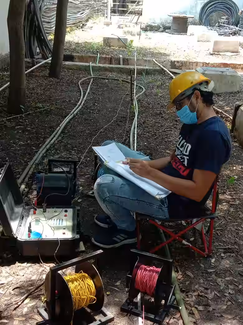
GPR Work Services in Indore, Madhya Pradesh
Accurate knowledge of underground features before carrying out construction, excavation, drilling, and infrastructure projects is vital. Pipeline, underground electrical cables, underground utilities, concrete structures, and other obstacles underground may be hazardous and delay work processes. GPR work services in Indore, Madhya Pradesh help determine underground features using non-invasive investigation techniques.
Development of residential properties, industry construction, roads, commercial properties, and infrastructure in Indore is expanding. With time, modern construction activities require pre-construction investigations using underground scanning and utility mapping techniques. GPR work services have become common for investigating underground utilities, underground objects, and voids among others without damaging the surface.
Website: www.asurvey.in
GPR Work is the geophysical investigation technique that makes use of electromagnetic radar waves to carry out surveys below the ground and discover any features underground.
The survey process allows us to discover the following underground features:
Pipelines
Electrical Cables
Water Pipelines
Sewage Systems
Buried Objects
Underground Void Areas
Rebars
Concrete Structure
Other Utility Features
Unlike conventional methods, GPR survey does not involve excavation and surface damage.
Before excavation or construction begins, understanding underground conditions is essential. Unknown underground utilities can result in costly damage, safety hazards, and project delays.
Underground Utility Detection
Utility detection is one of the major applications of GPR technology. Underground mapping helps identify buried services before drilling, excavation, or trenching work starts.
GPR systems are commonly used to detect:
Professional utility mapping supports safer construction execution.
Safer Excavation Planning
Excavation without underground investigation can create operational and structural risks. GPR work helps contractors and engineers plan excavation activities with better accuracy.
Accurate underground scanning helps reduce accidental utility strikes, project interruptions, and repair expenses.
Faster Project Planning
Reliable survey information improves construction scheduling, engineering coordination, and decision-making.
Underground utility detection is essential for construction, infrastructure, industrial, and redevelopment projects.
Utility mapping services help identify hidden assets before:
Ground Penetrating Radar is widely used in construction and civil engineering projects because it provides underground information without disturbing the site.
Concrete scanning is another important application of GPR technology.
Concrete scanning helps identify hidden elements inside concrete structures.
These may include:
Concrete scanning is useful before:
Proper scanning reduces the possibility of structural damage during construction activities.
GPR work supports multiple industries and engineering sectors.
Construction Projects
Construction projects require underground investigation before excavation, foundation work, and structural development.
Road and Highway Projects
Road construction and pavement works often require underground utility identification and subsurface mapping.
Industrial Facilities
Factories, warehouses, manufacturing plants, and industrial sites use GPR surveys for utility management and underground assessments.
Infrastructure Development
Metro projects, bridges, public works, utilities, and engineering developments depend on accurate subsurface investigation.
Residential and Commercial Developments
Residential buildings, commercial properties, malls, and office complexes benefit from underground scanning before construction activities begin.
Professional Ground Penetrating Radar services provide several important benefits for construction and engineering projects.
Non-Destructive Investigation
GPR surveys do not require excavation, drilling, or surface damage.
Accurate Underground Information
The technology helps identify hidden utilities, buried objects, and subsurface anomalies.
Improved Construction Safety
Proper underground mapping reduces construction hazards and utility damage risks.
Better Engineering Decisions
Reliable data supports improved planning, project management, and construction execution.
Cost and Time Savings
Early underground detection helps avoid delays, repairs, and unexpected project expenses.
GPR Survey Process
Professional GPR work generally follows a structured investigation process.
Site Assessment
The survey area is reviewed to understand project conditions and investigation requirements.
Data Collection
Ground Penetrating Radar equipment scans the site to collect underground information.
Data Interpretation
Radar signals are analyzed to identify utilities, structures, and subsurface conditions.
Reporting and Mapping
Survey findings are documented for engineering planning, utility mapping, and construction use.
Many construction challenges occur because underground conditions are unknown before excavation begins. GPR investigation helps reduce engineering uncertainty and improve planning.
GPR surveys support:
These services are valuable for both new construction projects and existing site developments.
GPR Work Services in Indore, Madhya Pradesh are important for underground utility detection, concrete scanning, subsurface mapping, and construction safety. Whether the project involves residential construction, industrial development, infrastructure works, or commercial projects, professional GPR investigation helps improve planning and reduce project risks.
Ground Penetrating Radar technology provides accurate underground information without excavation, supporting safer construction and better engineering outcomes.
For professional GPR survey and underground investigation solutions, visit: www.asurvey.in