Amazing Limited Time Offer !
Call : +91 7771811100, +91 7771811104
Accurate Surveying and Construction



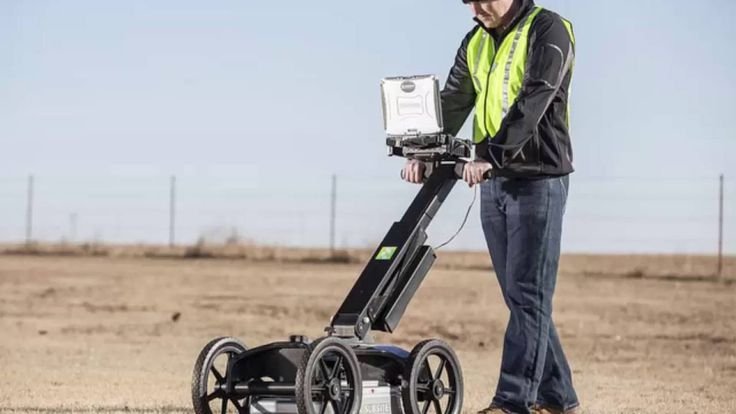
Construction and infrastructure projects require reliable underground information before excavation or structural work begins. Hidden electrical cables, pipelines, reinforcement, voids, and buried obstructions can cause unexpected challenges and increase project risks. Ground Penetrating Radar Survey in Surat offers a non-destructive method to investigate detectable subsurface features without relying solely on excavation. GPR uses electromagnetic signals to detect reflections from underground objects and changes beneath the surface.
Accurate Surveying and Construction provides GPR and other specialized surveying services tailored for construction, infrastructure, industrial, mining, road, and pipeline projects. The company combines advanced surveying technology with professional field expertise to enhance project planning and investigation accuracy.
Ground Penetrating Radar (GPR) is a geophysical technique used to detect variations and objects beneath the surface. It works by sending electromagnetic signals into the ground or materials, which reflect back when they hit different substances or buried objects. The reflected signals are collected and processed to generate a subsurface profile.
GPR can identify underground utilities, reinforcement, voids, concrete features, and other anomalies depending on site conditions and equipment setup. In places like Surat, a professional GPR survey is valuable for understanding underground conditions before starting disruptive construction projects.
Construction sites often hide critical underground infrastructure such as electrical cables, water pipelines, drainage, and communication lines. Damaging these can cause delays, repair costs, safety hazards, and service interruptions. A Ground Penetrating Radar (GPR) Survey helps project teams understand subsurface conditions before excavation or drilling, reducing risks.
For existing structures, GPR is valuable to investigate concrete, locate reinforcements, and detect internal anomalies, aiding renovation, structural assessment, and repair planning.
Underground Utility Mapping
Locates buried utilities and their positions, especially when existing drawings are incomplete or unavailable.
Reinforcement Detection
Identifies reinforcement in concrete to guide safe drilling, cutting, or coring.
Void and Anomaly Detection
Detects subsurface voids and irregularities that may pose construction risks.
Road and Pavement Investigation
Examines subsurface layers and anomalies beneath roads, parking lots, and paved surfaces.
Building and Structural Investigation
Provides internal structural information during renovation or assessment without destructive methods.
Infrastructure Projects
Supports large projects like roads, bridges, and industrial facilities with subsurface mapping before construction.
Site Assessment:
Review project area, existing drawings, and investigation goals.
Survey Planning:
Determine survey lines, scanning directions, and coverage based on site and project needs.
GPR Data Collection:
Move the GPR equipment over the surface, sending electromagnetic signals into the ground or structure.
Data Processing:
Analyze radar signals with software to identify subsurface reflections and patterns.
Interpretation:
Experts interpret data to locate utilities, reinforcement, voids, or anomalies.
Reporting:
Document findings with survey drawings, marked locations, profiles, and technical notes as required.
Non-Destructive Investigation:
GPR surveys detect subsurface features without excavation or damage to surfaces.
Improved Construction Safety:
Identifies underground utilities and structural elements, helping prevent accidental damage during digging or drilling.
Reduced Project Disruption:
Provides subsurface data with minimal surface disturbance compared to trial excavations.
Better Project Planning:
Supports engineers, contractors, and managers in planning excavation, cutting, renovation, and construction activities.
Faster Site Investigation:
Efficiently scans large areas for preliminary or targeted assessment.
Survey quality depends on equipment, planning, fieldwork, data processing, and expert interpretation. Site conditions and materials influence radar performance. Experienced professionals ensure accurate and reliable results aligned with engineering needs.
Early investigation helps avoid costly subsurface surprises.
As Surat grows rapidly with various projects, understanding underground conditions is critical. GPR surveys provide valuable information to enhance safety, planning, and decision-making.
While GPR doesn’t replace all geotechnical or structural tests, it plays a key role in comprehensive site investigations, reducing uncertainty before construction starts.
As Surat's skyline and infrastructure continue to expand, the risk of encountering unknown underground utilities increases. A professional Ground Penetrating Radar (GPR) Survey in Surat is not just an optional extra—it is a crucial step to protect your project, budget, and the safety of everyone involved.
A reliable survey combines advanced technology, experienced surveyors, and a proven process to deliver dependable GPR services across Surat, whether you are building new structures, excavating, or inspecting existing ones.