Amazing Limited Time Offer !
Call : +91 7771811100, +91 7771811104
Accurate Surveying and Construction



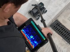
Modern infrastructure projects require precise knowledge of underground conditions before excavation or construction to avoid challenges from buried utilities and obstructions. Ground Penetrating Radar (GPR) Survey in Chhattisgarh offers a non-destructive technique to detect and map subsurface features. GPR uses electromagnetic signals to reveal underground conditions by analyzing reflected signals.
Accurate Surveying and Construction delivers expert surveying and consultancy services with advanced equipment and skilled civil engineers. Their services include GPR, DGPS, drone surveys, geophysical, geotechnical, mine, pipeline, topographical, and other specialized surveys, ensuring reliable subsurface information for construction projects.
Ground Penetrating Radar (GPR) is a geophysical survey technique used to investigate subsurface conditions without the need for extensive excavation.
GPR technology helps detect and map various underground features, including:
The depth and accuracy of detection depend on several factors such as soil conditions, material properties, moisture content, antenna frequency, and the nature of the target.
Because of these variables, professional survey planning and expert data interpretation are critical to obtaining accurate and useful results.
Rapid Urban and Industrial Growth
Cities like Raipur, Bilaspur, Durg, and Bhilai are experiencing continuous construction activity, increasing the likelihood of encountering unknown underground utilities.
Risk of Utility Damage
Accidentally striking buried gas lines, electrical cables, or water pipelines during excavation can lead to serious safety incidents and expensive repairs. GPR surveys help identify these risks in advance.
Better Project Planning
Accurate subsurface data allows engineers to design foundations, plan trenching routes, and estimate costs with much greater confidence.
Regulatory and Safety Compliance
Many infrastructure projects and government tenders now require documented subsurface investigations as part of due diligence and safety standards.
Underground Utility Detection
GPR helps locate underground utilities before excavation, especially useful in developed areas with multiple buried services.
Concrete Investigation
It assists in identifying reinforcement and internal features within concrete structures, aiding planning for drilling, cutting, renovation, or repairs.
Void Detection
GPR detects underground voids and cavities that may pose risks to construction and infrastructure stability.
Road Investigation
Useful for road and pavement projects, GPR reveals subsurface conditions and anomalies without extensive surface disruption.
Construction Planning
Provides valuable subsurface data before excavation or foundation work, complementing other investigation methods.
Non-Destructive Approach
Investigates subsurface conditions without extensive excavation, ideal for roads, buildings, industrial sites, and developed areas.
Better Site Understanding
Offers detailed information on detectable underground features before construction begins.
Reduced Excavation Risk
Identifies approximate locations of underground features, enabling safer and more precise excavation planning.
Minimal Site Disruption
Limits surface disturbance, allowing investigations across multiple areas with minimal impact on existing infrastructure.
Support for Engineering Decisions
Complements other surveys, providing engineers with a more comprehensive understanding of subsurface conditions.
A professional GPR survey in Chhattisgarh typically follows these steps:
Project Understanding
Review project requirements, site conditions, available drawings, and survey objectives.
Site Preparation
Identify the survey area and establish scanning paths based on project needs.
GPR Scanning
Move the GPR equipment across the area to record reflected electromagnetic signals from subsurface features.
Data Collection
Collect and organize radar data for further analysis.
Data Interpretation
Analyze data to identify relevant reflections, anomalies, and underground features.
Technical Reporting
Prepare survey outputs and technical reports for use by engineers, contractors, consultants, or project owners.
Construction & Infrastructure
Supports excavation, renovation, and infrastructure development by locating subsurface features.
Mining & Mineral Projects
Important for mining sector infrastructure and planning. Survey services also include DGPS, Total Station, drones, GIS, and 3D terrain modeling.
Industrial Projects
Provides information on complex underground utility networks before modifications or expansions.
Roads & Pipelines
Assists in route planning and excavation with detailed subsurface investigation.
Dams & Hydro Projects
Combines GPR with other investigation methods to enhance site understanding for large infrastructure projects.
ASurvey serves these key sectors, delivering specialized surveying solutions tailored to each industry's unique needs.
Traditional Excavation
Physically exposes underground features but can disturb roads, floors, concrete, landscaping, and existing infrastructure.
Ground Penetrating Radar (GPR)
Investigates subsurface conditions non-destructively without immediate extensive excavation. Serves as a vital preliminary investigation method.
Important Note
GPR results should be interpreted with consideration of site conditions and, if necessary, verified through complementary investigation methods.
Statewide Coverage
Serving major cities and remote industrial sites across Chhattisgarh.
Modern Equipment
Updated GPR technology ensures higher accuracy and better depth penetration.
Skilled Surveyors
Experienced team adept at interpreting complex subsurface data.
Clear Reporting
Easy-to-understand reports with visual mapping, not just raw data.
Reliable Turnaround
Timely delivery to keep your project on schedule.
Q1. Is a Ground Penetrating Radar Survey necessary for small projects?
Yes. Even small residential or commercial projects can encounter buried utilities. Surveys help avoid unexpected damage regardless of project size.
Q2. How deep can GPR detect objects underground?
Depth depends on soil type and equipment, but GPR typically detects utilities and structures several meters below the surface.
Q3. Does the survey damage the site?
No. GPR is completely non-invasive with no digging or drilling required.
Q4. How long does a typical survey take?
Duration varies by site size and complexity. Asurvey ensures efficient scanning and prompt report delivery.
Q5. Can GPR surveys be used for both urban and rural sites?
Yes. Asurvey conducts surveys across varied terrains, from dense urban areas to open industrial and rural lands in Chhattisgarh.
Accurate underground information simplifies planning and execution of construction and infrastructure projects. GPR offers a practical, non-destructive method for subsurface investigation across applications like utility mapping, concrete assessment, roads, industrial sites, pipelines, and more.
A Ground Penetrating Radar Survey in Chhattisgarh helps project owners, engineers, contractors, and consultants detect underground features before excavation begins, reducing risks and improving project outcomes.
By combining advanced GPR technology with expert surveying, project teams gain better site understanding, enhance excavation safety, and make informed engineering decisions.
For comprehensive subsurface insights, GPR surveys can be integrated with DGPS, topographical, geotechnical, mining, drone, and other specialized services provided by Accurate Surveying and Construction.